Roaring Brook Falls
New Haven County, Connecticut
Your visit at a glance
- Waterfall height
- Not recorded
- Location
- New Haven County, Connecticut
- Access status
- Town trail and public parking documented; distance to falls not measured
- The walk
- Less than 1.3 miles each way; no exact distance to the falls is published
- Ground & access
- Steep climb beside a deep ravine, about 400 feet of gain over the full trail. Blazes are sparse and social trails are common, so stay on the blazed trail and away from the ravine edge.
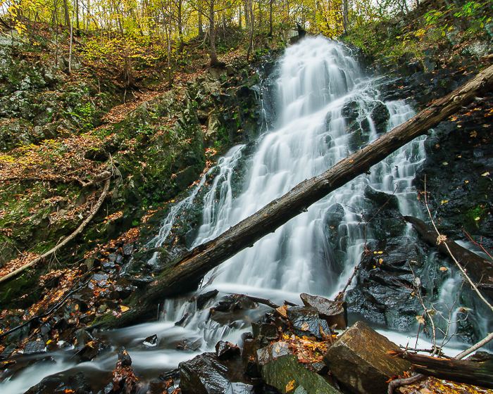
Roaring Brook Falls is an 80-foot set of falls in a deep ravine in Cheshire town open space. From the trailhead kiosk on Roaring Brook Drive, follow the trail past a small pond and an old chimney into the woods, then climb beside the brook. The falls can be heard and then seen from the steep section of trail. The trail continues up to the blue-blazed Quinnipiac Trail. Return the same way.
Plan your visit
Roaring Brook Drive trailhead kiosk to Roaring Brook Falls on the orange trail
Hiking Project gives 1.3 miles point to point for the whole Roaring Brook Trail up to the Quinnipiac Trail. The falls are partway along it, so the walk to the falls is shorter. No measured distance to the falls was found.
Steep climb beside a deep ravine, about 400 feet of gain over the full trail. Blazes are sparse and social trails are common, so stay on the blazed trail and away from the ravine edge.
Where to start
Public parking at the trailhead kiosk on Roaring Brook Drive, Cheshire, according to the town brochure. The brochure map also shows on-street parking.
Timing & water
Best in spring from April to June when the brook runs strong. Current trail conditions were not checked.
Before you go
Town open space. No fee or reservation is mentioned. The brochure lists hiking and dogs on leash as permitted uses.
Visitor informationMore waterfalls nearby
Within 40 straight-line miles. Road and trail distances will differ.
- CascadeNew Haven County, CT0.1 miW
- Intermittent CascadePublished trail route and parking documented; seasonal flowNew Haven County, CT4.3 miSE
- Hopp Brook FallsPartial guide: guidebook route; land ownership not confirmed; off-trail scrambleNew Haven County, CT5.0 miSW
- Wolcott FallsShort land trust path and street parking documented23 ft (7 m) · New Haven County, CT5.6 miS
- Spruce Brook FallsPartial guide: which Spruce Brook drop this point marks is unconfirmed; 2024 flood damageNew Haven County, CT6.6 miW
- Spruce Brook FallsNew Haven County, CT6.8 miW
- Sperry FallsShort park path and seasonal parking documented; winter gate10 ft (3 m) · New Haven County, CT7.3 miS
- Spruce Glen FallsFirsthand land trust loop route and parking documentedNew Haven County, CT7.8 miE
- Wepawaug FallsShort published route and parking documentedNew Haven County, CT9.3 miSW