Ouzel Falls
Boulder County, Colorado
Your visit at a glance
- Waterfall height
- Not recorded
- Location
- Boulder County, Colorado
- Access status
- Published trail route and trailhead parking documented; park entry rules apply
- The walk
- About 2.7 miles each way; 5.4 miles round trip
- Ground & access
- Steady forest trail with about 870 feet of total climbing per the source. The source says the better viewpoint beyond the footbridge now requires a short off-trail scramble since the 2013 flood.
Follow the Wild Basin trail from the trailhead past Copeland Falls, cross Sandbeach Creek, and stay left at the campsite spur near 1.3 miles. Pass Calypso Cascades near 1.8 miles and continue to the footbridge over Ouzel Creek at about 2.7 miles, where the falls are visible. Return the same way.
Plan your visit
Wild Basin Trailhead to Ouzel Falls
Rocky Mountain Hiking Trails gives 2.7 miles from the trailhead to the falls and 5.4 miles round trip.
Steady forest trail with about 870 feet of total climbing per the source. The source says the better viewpoint beyond the footbridge now requires a short off-trail scramble since the 2013 flood.
Where to start
Wild Basin Trailhead parking lot at the end of the Wild Basin Road, about 2.2 miles from the park turn-off on a narrow gravel road. The source gives parking coordinates 40.20883, -105.56614. From Estes Park, drive 12.6 miles south on Colorado Highway 7, turn right on Wild Basin Road, then right into the park after 0.4 miles.
Timing & water
Flow is strongest during spring and early summer snowmelt. Current road and trail conditions were not checked for a specific date.
Before you go
A park entrance pass is required at all times. In 2026 a timed entry reservation was also required to enter between 9 a.m. and 2 p.m. from May 22 to October 12. Check the park site for the current season.
Visitor informationVisit sources
More waterfalls nearby
Within 40 straight-line miles. Road and trail distances will differ.
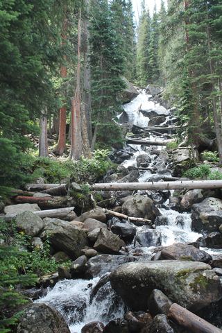 Calypso CascadesOfficial trail distance and park entry rules documentedBoulder County, CO0.6 miSE
- Hidden FallsPartial guide: winter climbing approach only; exact distance and summer route unknownBoulder County, CO1.3 miE
- Upper Copeland FallsPublished trail route and trailhead parking documented; park entry rules applyBoulder County, CO1.5 miE
- Lower Copeland FallsPublished trail route and trailhead parking documented; park entry rules applyBoulder County, CO1.6 miE
- Lyric FallsPartial guide: last 0.75 mile is an unmaintained social trail with no markerBoulder County, CO1.8 miN
- Copeland FallsPublished trail distance and park entry rules documentedBoulder County, CO1.8 miE
- Mertensia FallsBoulder County, CO2.3 miNW
- Thunder FallsBoulder County, CO2.8 miNW
- Trio FallsBoulder County, CO3.4 miNW