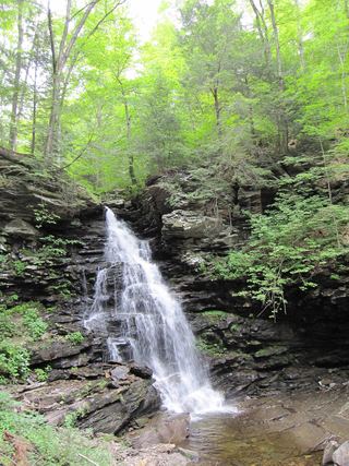
Wyandot Falls
Luzerne County, Pennsylvania
Your visit at a glance
- Waterfall height
- 15 ft (4.6 m)
- Location
- Luzerne County, Pennsylvania
- Access status
- Official state park trail and parking documented
- The walk
- Distance from the trailhead to this falls not stated; it is 0.09 mile upstream of Waters Meet
- Ground & access
- Rocky, steep and often wet trail along the gorge with many stone steps. DCNR rates the Falls Trail System most difficult and requires sturdy boots; sneakers, sandals and water shoes are not advised.
Wyandot Falls is on the Glen Leigh branch of Kitchen Creek inside the Glens Natural Area of Ricketts Glen State Park. It is the first named falls in Glen Leigh counting upstream from Waters Meet. From Beach Lot #2, follow signs down the trail beside the cabin road to the Glen Leigh side of the Falls Trail, then descend along the glen to Wyandot Falls. Return the same way, or follow DCNR's recommended 3.2-mile clockwise loop from Lake Rose Trailhead: Highland Trail to the Glen Leigh side, down to Waters Meet, then up the Ganoga Glen side. Wyandot is a 15-foot falls and is visible from Waters Meet, so it can also be reached from the Evergreen Parking area on PA 118 by following the Falls Trail north to Waters Meet.
Plan your visit
Beach Lot #2 Trailhead down the Glen Leigh side of the Falls Trail to Wyandot Falls
DCNR gives a 1-mile hike from Beach Lot #2 to the closest waterfall and 1.0 mile for the Glen Leigh side of the Falls Trail. Wikipedia places Wyandot Falls 0.09 mile upstream of Waters Meet. From the south, DCNR gives 2.0 miles on the Falls Trail from PA 118 to Waters Meet.
Rocky, steep and often wet trail along the gorge with many stone steps. DCNR rates the Falls Trail System most difficult and requires sturdy boots; sneakers, sandals and water shoes are not advised.
Where to start
Beach Lot #2 Trailhead Parking, the closest access to the Glen Leigh side of the Falls Trail. Follow signs out of the lot and down the trail beside the cabin road for 0.5 mile. Lake Rose Trailhead Parking (41.329880, -76.291092) is the other upper start. The park office is at 695 State Route 487, Benton, PA.
Timing & water
DCNR closes the Falls Trail System in winter except to properly equipped ice climbers and hikers. Plan to be off the trail well before dark.
Before you go
No fee is mentioned.
Visitor informationVisit sources
More waterfalls nearby
Within 40 straight-line miles. Road and trail distances will differ.
- B. Reynolds FallsState park trail down the Glen Leigh side of the Falls Trail40 ft (12.2 m) · Luzerne County, PA0.0 miN
- R.B. Ricketts FallsOfficial state park trail and parking documented36 ft (11 m) · Luzerne County, PA0.2 miN
- Erie FallsOfficial Falls Trail from Lake Rose Trailhead; distance to this falls not given47 ft (14.3 m) · Luzerne County, PA0.2 miW
- Tuscarora FallsOfficial Falls Trail from Lake Rose Trailhead; distance to this falls not given41 ft (12.5 m) · Luzerne County, PA0.2 miW
- Harrison Wright FallsState park trail from the Glens Lot on PA 11827 ft (8.2 m) · Luzerne County, PA0.2 miS
 Ozone FallsOfficial Falls Trail from Beach Lot #2; distance to this falls not given60 ft (18.3 m) · Luzerne County, PA0.3 miN
- Sheldon Reynolds FallsState park trail from the Glens Lot on PA 11836 ft (11 m) · Luzerne County, PA0.3 miS
- Conestoga FallsOfficial state park trail and parking documented17 ft (5.2 m) · Luzerne County, PA0.3 miW
- Murray Reynolds FallsOfficial state park trail, parking and distance documented16 ft (4.9 m) · Luzerne County, PA0.4 miS