Jarrett Falls
Fulton County, Pennsylvania
Your visit at a glance
- Waterfall height
- 7 ft (2 m)
- Location
- Fulton County, Pennsylvania
- Access status
- Named State Game Lands trail with wet, cable-assisted stream crossings
- The walk
- About 1.8 miles one way, per Uncovering PA
- Ground & access
- Mostly gentle trail losing about 300 feet, with irregular red blazes, at least two wet stream crossings without bridges, cable-assisted crossings and possible fallen trees. Not well suited to small children.
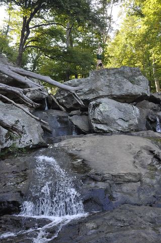
Jarrett Falls is a tiered falls of about 15 feet on Roaring Run in State Game Lands 53, southwest of McConnellsburg. From the parking area at the end of the road by the Meadow Grounds Lake dam, cross to the west side of the dam. Near the flood spillway, a stone marker shows the start of the Jarrett Trail; turn left, cross the spillway and follow the trail downstream along Roaring Run. After about half a mile, at a clearing, cross the footbridge over Roaring Run and continue down the left bank (facing downstream). Cross a second bridge, then make two wet crossings: the first has a chained ladder up the far bank, and at the second, where the trail seems to end at a large rock, steel cables help the descent and the crossing. Continue downstream to the top of the falls. Reaching the base needs a risky crossing above the falls and is not recommended. Return the same way.
Plan your visit
Meadow Grounds Lake dam parking, across the dam to the Jarrett Trail marker, then the Jarrett Trail down Roaring Run to the top of Jarrett Falls
Uncovering PA gives roughly 1.8 miles from the Meadow Grounds Lake dam parking to the falls, and a 1.8-mile hike back the same way. PA Bucket List places the falls roughly 1.7 miles downstream of Meadow Grounds Lake.
Mostly gentle trail losing about 300 feet, with irregular red blazes, at least two wet stream crossings without bridges, cable-assisted crossings and possible fallen trees. Not well suited to small children.
Where to start
Parking area at the end of the road beside the Meadow Grounds Lake dam, reached by a few miles of dirt road that Uncovering PA drove in a regular car. Published coordinates 39.904911, -78.057623.
Timing & water
Wet crossings are harder in high water.
Before you go
No fee is mentioned. State Game Lands allow hunting; Uncovering PA recommends wearing blaze orange.
Visitor informationVisit sources
- Uncovering PA: How to Get to Jarrett Falls Near McConnellsburg
- Uncovering PA: How to Get to Jarrett Falls Near McConnellsburg
- Uncovering PA: How to Get to Jarrett Falls Near McConnellsburg
- Uncovering PA: How to Get to Jarrett Falls Near McConnellsburg
- Uncovering PA: How to Get to Jarrett Falls Near McConnellsburg
- Uncovering PA: How to Get to Jarrett Falls Near McConnellsburg
- PA Bucket List: Must-See Attractions in Fulton County
More waterfalls nearby
Within 40 straight-line miles. Road and trail distances will differ.