Rynex Kill Falls
Schenectady County, New York
Your visit at a glance
- Waterfall height
- 39 ft (12 m)
- Location
- Schenectady County, New York
- Access status
- Partial guide: view of the top only from the Red Trail; base route not described
- The walk
- Within about 0.6 miles of the lot
- Ground & access
- Roots and rocks on the rim trail with hills. Unstable cliff edges near the falls; people have been seriously hurt or killed here. Stay back from the edge.
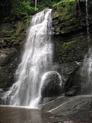
Rynex Kill Falls, also called Rynex Creek Falls, is a 40-foot falls on Rynex Creek where it enters the Plotter Kill in the Plotter Kill Preserve, Rotterdam. From the Mariaville Road lot, follow the Red Trail along the rim past the tops of Upper and Lower Falls; the trail then pulls away from the creek and descends toward Rynex Creek. Only the top of the falls can be seen from the Red Trail. One visitor account calls the main falls very tough to reach and deadly on a wet slope. No described route reaches the base. Return the same way.
Plan your visit
Plotter Kill Preserve lot on Mariaville Road (Route 159), Red Trail past the tops of Upper and Lower Falls to the top of Rynex Creek Falls
Uncovering New York says the Red Trail passes the tops of all three large falls within the first 0.6 miles. No source gives a separate figure for Rynex Creek Falls.
Roots and rocks on the rim trail with hills. Unstable cliff edges near the falls; people have been seriously hurt or killed here. Stay back from the edge.
Where to start
Preserve lot on Mariaville Road (Route 159), 1.9 miles after turning onto Route 159 from Putnam Road.
Timing & water
Open dawn to dusk. The falls are largest in spring high water.
Before you go
No fee is mentioned. Carry in, carry out.
Visitor informationVisit sources
More waterfalls nearby
Within 40 straight-line miles. Road and trail distances will differ.
 Lower Plotter Kill FallsPartial guide: view from near the top edge only; base route not described39 ft (12 m) · Schenectady County, NY0.1 miS
 Upper Plotter Kill FallsCounty preserve overlook; steep marked path to the base59 ft (18 m) · Schenectady County, NY0.2 miSW
- Sergeant FallsSchenectady County, NY0.8 miNE
- Jacob's Ladder FallsPartial guide: preserve trail to a nearby cascade; the last part follows the stream bed and the name's extent is unclearSchenectady County, NY1.4 miNE
- First Falls7 ft (2 m) · Saratoga County, NY7.0 miNE
- Second Falls10 ft (3 m) · Saratoga County, NY7.1 miNE
- Bozen KIll FallsPartial guide: preserve trail documented; this listing is probably the Christman Sanctuary falls, but no source ties it to this location49 ft (15 m) · Schenectady County, NY7.2 miSW
- Third Falls3 ft (1 m) · Saratoga County, NY7.3 miNE
- Buttermilk Falls33 ft (10 m) · Albany County, NY8.8 miS