Rock Falls
Norfolk County, Massachusetts
Your visit at a glance
- Waterfall height
- Not recorded
- Location
- Norfolk County, Massachusetts
- Access status
- Town walkway and boardwalk to a viewing platform; easy
- The walk
- About 0.33 mile one way, about 0.7 mile return
- Ground & access
- Easy. Paved path and wide boardwalk, listed as ADA-compliant.
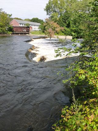
Rock Falls is a ledge drop on the Monatiquot River in Braintree where a pool and weir fishway was built during the river restoration project. From Plain Street, a paved path leads to a wide wooden boardwalk heading north along the river past the former Armstrong and Ames dam sites. After about 0.15 mile the path is paved again and ends at a viewing platform above the fish ladder at Rock Falls. Return the same way.
Plan your visit
Monatiquot River Walkway from Armstrong Park at Plain and Hancock Streets, Braintree, to the Rock Falls fish ladder platform
The North and South Rivers Watershed Association gives a total trail length of 0.33 miles from Plain Street to the viewing platform. The return figure is derived by doubling it.
Easy. Paved path and wide boardwalk, listed as ADA-compliant.
Where to start
Ample on-site parking at Armstrong Park, at the corner of Plain and Hancock Streets (listed address 24 Plain St, Braintree).
Timing & water
Listed hours are dawn to dusk. Herring run in mid to late spring.
Before you go
Free, per the watershed association listing. No reservation mentioned.
Visitor informationVisit sources
More waterfalls nearby
Within 40 straight-line miles. Road and trail distances will differ.
- Cascade FallsShort trail route and street parking documentedMiddlesex County, MA17 miN
 Wamesit FallsOverlook named on a city greenway; exact position not confirmedMiddlesex County, MA33 miNW
- Cascade Brook FallsConservation area trail and parking documentedProvidence County, RI37 miSW
 Newbury FallsEssex County, MA38 miN