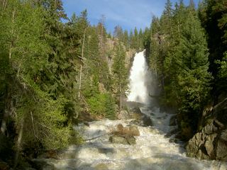
Fish Creek Upper Falls
Routt County, Colorado
Your visit at a glance
- Waterfall height
- Not recorded
- Location
- Routt County, Colorado
- Access status
- Published route, distance and day-use fee documented
- The walk
- About 5.5 miles return
- Ground & access
- Steady climb from about 7,340 feet at the base of the lower falls to about 9,000 feet. Rocky trail.
From Lincoln Avenue (US 40) in Steamboat Springs, go north on 3rd Street and right on Fish Creek Falls Road for four miles to the trailhead. Take the dirt trail 1/4 mile to the bridge at the base of the lower falls. Continue up the trail about 2.5 miles to Upper Fish Creek Falls. Return the same way.
Plan your visit
Fish Creek Falls Trailhead via the lower falls bridge and Fish Creek Falls Trail to Upper Fish Creek Falls
Steamboat Chamber lists 1/4 mile one way from the trailhead to the bridge at the base of the lower falls, then 2.5 miles one way to the second waterfall. Return distance is derived by doubling.
Steady climb from about 7,340 feet at the base of the lower falls to about 9,000 feet. Rocky trail.
Where to start
Trailhead parking at 34165 Fish Creek Falls Road. Use is heavy, especially mid-day.
Timing & water
Steamboat Chamber says the site is open year round, 6 am to 10 pm daily. Snow covers the upper trail in winter.
Before you go
Steamboat Chamber lists a $5 vehicle day-use fee, cash or check.
Visitor informationMore waterfalls nearby
Within 40 straight-line miles. Road and trail distances will differ.