Washburn Falls
Florence County, Wisconsin
Your visit at a glance
- Waterfall height
- 7 ft (2 m)
- Location
- Florence County, Wisconsin
- Access status
- Partial guide: rough 4-mile gravel road; land ownership at the falls not confirmed
- The walk
- 400-foot trail to the falls per American Whitewater
- Ground & access
- Short, easy trail. Banks near the lower falls are steep; view from a distance rather than climbing down.
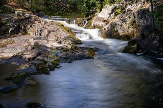
Washburn Falls is a close set of cascades and drops on the Popple River near Fern in Florence County, on a stretch designated a State Wild River. American Whitewater says the falls can be reached by White Ash Road, a gravel road and ATV trail about 4 miles long whose last half is often rough, and that a parking lot and a 400-foot trail to the falls are on the left. A visitor account describes a short, easy walk from a gravel parking area to a side view of the largest single drop, with the lower cascades downstream. Return the same way. The same source says over 95 percent of the land along this stretch is owned by the Wisconsin DNR and Florence County; ownership at the falls itself is not stated.
Plan your visit
White Ash Road (gravel) to the Washburn Falls parking lot, then a 400-foot trail to the Popple River
American Whitewater gives a 400-foot trail from the parking lot to the falls. The 4-mile figure in the same source is the gravel road drive, not a walk.
Short, easy trail. Banks near the lower falls are steep; view from a distance rather than climbing down.
Where to start
Gravel parking lot on the left of White Ash Road at the trail to the falls. The gravel road is often rough on its last half, and driving in from the east can be rougher or impassable.
Timing & water
No season or hours are stated. Road conditions can make the drive rough or impassable.
Before you go
No fee is mentioned.
Visitor informationVisit sources
More waterfalls nearby
Within 40 straight-line miles. Road and trail distances will differ.
- Jennings Falls11 ft (3.3 m) · Florence County, WI1.7 miN
- LaSalle FallsAbout 1 mile through woods from a parking lot22 ft (6.7 m) · Florence County, WI3.8 miE
- Fumee Creek FallsRoadside wayside viewpoint documentedDickinson County, MI19 miE
- Upper Fumee Creek FallsPartial guide: wayside and stair documented; view of the upper drops not confirmedDickinson County, MI19 miE
- Eighteen Foot FallsCounty-listed waterfall with a short signed trail from a turnaround parking spotMarinette County, WI19 miSE
- Strong FallsCounty park walk to the fallsMarinette County, WI20 miS
 Horseshoe FallsCounty forest waterfall with a short trail from a forest road parking area; roads can be roughMarinette County, WI21 miSE
- Bull FallsPartial guide: short overgrown path; land ownership not statedMarinette County, WI29 miSE
- SpillwayMarinette County, WI38 miS